Synopsis:.
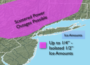
A low just to our South will result in periods of rain and freezing rain today. Up to a quarter inch of glaze is possible with isolated 1/2″ glaze amounts. Ice accumulation of this magnitude may cause scattered power outages and downed tree limbs. Please use caution.
The low will move off the coast tonight. Rain and freezing rain will taper off by evening. There will be icy conditions overnight despite the clearing skies as readings will fall below freezing throughout the region. Any moisture on surfaces will become slick.
Wednesday we’ll dry out under a mix of clouds and sun. It will turn dramatically colder by evening as an Arctic front moves through.
Thursday will be very cold with highs below freezing as the cold high move toward the area. Friday will be bright and cold with readings near freezing.
Readings will moderate to near seasonal averages on Saturday along with mainly sunny skies.
Stay Tuned.
Keep it here for a no hype, no nonsense forecast.
Today:
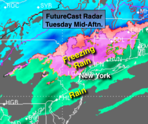
Rain along the coast, freezing rain where temperatures are at or below 32º. Many areas will go over to plain rain as the day goes on. Ice accumulation will be a concern. Highs around 40º along the coast, near freezing well inland. Northeast to North winds at 5-10mph.
Tonight:
Clearing skies. Lows around 30º in the City, the 20s inland. Northwest winds at 10-15mph.
Wednesday:
Partly sunny, windy and turning colder during the afternoon. Highs in the upper 30s in the morning with readings dropping to near freezing by late day.
Thursday:
Sunny and frigid. Highs only in the 20s.
Friday:
Sunny, cold. Highs near freezing.
Saturday:
Mostly sunny, more seasonal. Highs around 40º.