Synopsis:.
High pressure will move off the coast today. Temperatures will rebound some as the wind turns to the South.
Skies will become mostly cloudy overnight. It’ll be much milder than last night with readings above freezing throughout.
A storm will track from the Great Lakes into Eastern Canada Monday and Tuesday. This is a warm storm track for the East coast. Periods of rain are expected both days. It’ll feel more like Spring than early December.
By Wednesday, a cold front will swing through in the morning. The latest computer guidance suggests the rain will turn to a period of snow overnight Tuesday into Wednesday morning. If the leftover precipitation is heavy enough there could be some accumulation (this is in no way etched in stone) otherwise the sun will return with much colder readings during the afternoon.
Thursday will be freezing despite the abundant sunshine.
Weather whiplash the next 5 days. Hang on!
Stay Tuned.
Keep it here for a no hype, no nonsense forecast.
Today:
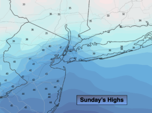
Mostly sunny. Not as harsh by afternoon. Highs in the lower to mid 40s. South winds at 5-10mph.
Tonight:
Becoming mostly cloudy. Much milder than last night. Lows in the lower 40s in the City, the 30s inland. Southwest winds less than 5mph.
Monday:
Periods of rain. Much milder. Highs in the mid 50s.
Tuesday:
Periods of rain. Balmy. Highs near 60º.
Wednesday:
The potential for a period of morning snow, otherwise becoming mostly sunny and colder. Highs only in the 30s.
Thursday:
Sunny and cold. Highs only in the upper 20s to around freezing in the City.