Synopsis:.
The storm that gave the region a wide range in snowfall, from 10″ over parts of Orange & Sussex counties to no accumulation (yes it was a “bust” over many areas) is moving East of Cape Cod. Any residual snow showers will end over Eastern areas this morning. Clouds will give way to sunshine. It will be windy and cold.
More tranquil conditions are expected for the rest of the week. Readings will be below the average high of 48º as a chilly Northwest wind prevails.
No major storms are on the horizon.
Stay Tuned.
Keep it here for a no hype, no nonsense forecast.
Today:
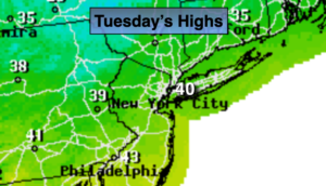
Early morning snow showers East, otherwise partly sunny, breezy and chilly. Highs around 40º. Northwest winds at 15-25mph with gusts to 30mph.
Tonight:
Becoming partly cloudy. Cold. Lows near freezing in the City, the 20s inland. West winds diminishing to 5-10mph.
Wednesday:
More clouds than sun. Highs in the lower 40s.
Thursday:
Partly sunny.. Highs in the lower 40s.
Friday:
Sun and clouds. Scattered flurries. Highs in the upper 30s.
Saturday:
Mostly sunny and cold. Highs in the mid 30s.