Synopsis:.
On the backside of high pressure, winds will be out of the Southwest today. This will cause the mercury to pop at least ten degrees compared to Saturday’s readings. Today will be the more comfortable day of the weekend under a mix of sun and clouds.
Veterans Day will be tranquil as high pressure remains offshore. Readings will be close to seasonal averages (the mid & upper 50s) under a mix of sun and clouds.
A significant cold front will approach the region on Tuesday. Morning showers have a decent chance of changing to snow showers as cold air comes rushing in. At this point this doesn’t look like a major concern with the white stuff. There is the potential for a coating of snow over the higher terrain. The sun will return during the afternoon. Temperatures will drop from morning highs in the 40s into the 30s and winds will increase.
The coldest airmass of the season will be will be upon us on Wednesday. Readings will only be near freezings for daytime highs.
Stay Tuned.
Keep it here for a no hype, no nonsense forecast.
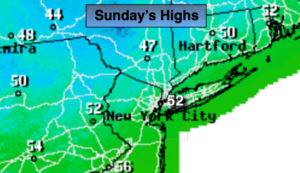
Today:
Partly sunny, not as cold. Highs in the lower 50s. Southwest winds at 8-12mph.
Tonight:
Mostly cloudy. Lows in the mid 40s in urban areas, the 30s in the ‘burbs. Southwest winds less than 5mph.
Monday (Veterans Day):
Partly sunny. More seasonal. Highs in the mid to upper 50s.
Tuesday:
Morning showers mostly likely changing to snow showers, especially inland. Becoming mostly sunny and breezy. Highs in the 40s with readings falling into the 30s during the afternoon.
Wednesday:
Mostly sunny, breezy and cold. Highs only in the lower to mid 30s.
Thursday:
Partly sunny. Chilly. Highs around 40º.