Synopsis:.
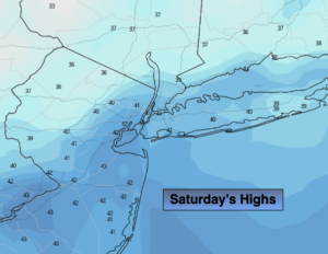
The weekend looks bright as high pressure works in. Saturday will be cold with nearly calm winds. On the backside of high winds will turn Southwest on Sunday. This will cause the mercury to pop at least ten degrees compared to Saturday’s readings. Sunday will be the more comfortable day of the weekend.
Veterans Day will be tranquil as high pressure remains offshore. Readings will be close to seasonal averages (the mid & upper 50s) under a mix of sun and clouds.
A significant cold front will approach the region on Tuesday. Showers are expected. The potential is there for snow showers inland depending on how everything falls into place. At this point this doesn’t look like a concern with the white stuff. One thing is for sure, very cold air will follow this system.
Stay Tuned.
Keep it here for a no hype, no nonsense forecast.
Today:
Sunny and high clouds. Cold. Highs in the lower 40s. Winds becoming South at 5-10mph.
Tonight:
Partly cloudy. Lows in the mid 30s in urban areas, the 20s in the ‘burbs. Southwest winds at 5-10mph.
Sunday:
Partly sunny, not as cold. Highs in the lower 50s.
Monday:
Partly sunny. More seasonal. Highs in the mid to upper 50s.
Tuesday:
Mostly cloudy. Showers likely. Potential for rain showers changing to snow showers inland. Highs in the 40s with readings falling later in the day.
Wednesday:
Mostly sunny, windy and cold. Highs only in the lower to mid 30s.