Synopsis:.
High pressure will basically dominate our weather through Thursday. This will result in plenty of sunshine the only exception will be on Tuesday. A weak front may throw more clouds our way. There’s a slight chance of a few showers at that time (but it won’t be a big deal). Readings will be at or below the seasonal average of 58º through the period.
By Thursday night into Friday a system needs to be watched. There is cold air filtering in from the North, but where will the ripple of low pressure move? The models continue to waver back and forth with the placement of the low. There is a low potential for some rain and a mix of rain and wet snow inland Thursday night. One thing looks for sure; it’ll get much colder later Friday into next weekend.
Stay Tuned.
Keep it here for a no nonsense, no hype forecast.
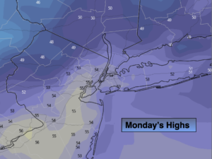
Today:
Sunny. Highs in the lower to mid 50s. Winds becoming South at 5-10mph.
Tonight:
Mostly cloudy. Not as cold as recent nights. Lows around 50º in the urban corridor, the 30s & 40s inland. Southwest winds 5mph.
Tuesday:
Mostly cloudy. Slight chance of showers. Highs in the upper 50s.
Wednesday:
Sunny. Highs in the lower to mid 50s.
Thursday:
Sun to clouds. Highs in the mid 50s. A potential for rain and a mix of rain/wet snow inland at night
Friday:
Mostly sunny, windy and cold. Highs in the lower 40s.