Synopsis:.
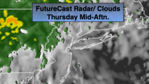
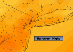
Halloween will be cloudy with on and off showers as a front moves toward the region from the West. It looks like there will be a window of mostly dry time, just in time for trick or treaters between 4-8pm. It will be warm with readings near 70º. Winds will increase during the day and become strong by evening.
Tonight a sharp cold front will work move through around midnight. Ahead of the front winds may gust up to 50mph from the Southwest. Just behind the front winds will switch to the West and be just as strong. Areas of torrential rain and thunderstorms will accompany the cold frontal passage.
Friday (November’s debut) will be mostly sunny and windy. High will remain in the mid 50s.
The weekend feature plenty of sun with more typical readings for early November as high pressure moves in from the West.
Stay Tuned.
Keep it here for a no nonsense, no hype forecast.
Halloween:
Cloudy with on and off showers. It should be mainly rain-free later in the day and early evening for the magical time-Halloween. Warm. Highs near 70º. South winds increasing to 15-25mph with gust to 45mph by evening, especially at the coast.
Tonight:
Very warm and mainly dry through mid evening. Showers and storms will move in between 10pm and 3am from West to East. Lows in the upper 40s to mid 50s. Windy. South wind will become West at 15-35mph with gusts to 5omph.
Friday:
Mostly sunny, windy and much cooler. Highs in the mid 50s.
Saturday:
Mostly sunny. Highs in the mid 50s.
Sunday:
Mostly sunny, chilly. Highs in the lower to mid 50s.
Monday:
Mostly sunny. Highs in the lower to mid 50s.