Synopsis:.
There will be a window of mostly dry time, just in time for trick or treaters between 5-9pm. It will be warm with readings near 70º. Winds will increase during the day and become strong by evening.
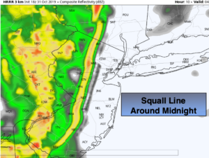
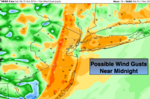
Tonight a sharp cold front will work move through around midnight. Ahead of the front winds may gust up to 50mph from the Southwest. Just behind the front winds will switch to the West and be just as strong. Areas of torrential rain and thunderstorms will accompany the cold frontal passage (first two maps above). Isolated power outages and downed trees are a possibility.
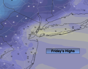
Friday (November’s debut) will be mostly sunny and windy. The winds will abate by midday. High will remain in the mid 50s.
The weekend feature plenty of sun with more typical readings for early November as high pressure moves in from the West.
Pleasant conditions are expected for the beginning of the week.
Stay Tuned.
Keep it here for a no nonsense, no hype forecast.
Tonight:
Very warm and mainly dry through mid evening. Showers and storms will move in between 10pm and 3am from West to East. Lows in the upper 40s to mid 50s. Windy. South wind will become West at 15-35mph with gusts over 5omph.
Friday:
Mostly sunny, windy and much cooler. Highs in the mid 50s. West winds at 15-35mph with gusts to 45mph in the morning. The winds will diminish rapidly by afternoon at 10-20mph.
Saturday:
Sunny. Highs in the lower to mid 50s.
Sunday:
Sunny, chilly. Highs near 50º.
Monday:
Mostly sunny. Highs in the lower to mid 50s.
Tuesday:
Mostly sunny, more seasonal. Highs in the upper 50s.