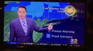
Frost & Freeze Alerts are up for tonight North & West of the City.
Synopsis:
High pressure over Eastern Canada will deliver mainly sunny, cool conditions for today. It will be windy with gusts between 30-35mph. Definitely a nip in the air. Tonight will be the coldest night of the season so far. Readings will drop into the 30s inland. A frost and or freeze may occur in the sheltered valleys over the far Northwestern valleys.
Saturday will be stellar with wall to wall crisp sunshine.
Sunday will be milder as the high slips offshore and a Southwesterly flow develops.
Showers are possible Monday as a front works in. It will be warm.
Stay Tuned.
Keep it here for a no nonsense, no hype forecast.
Today:
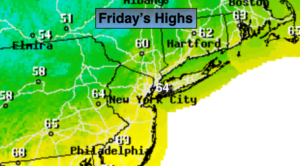
Mostly sunny, cool and windy. Highs in the mid 60s. Northwest winds at 15-35mph.
Tonight:
Clear and cold. Lows in the mid 40s in the City, the 30s inland. North winds diminishing to 5-10mph.
Saturday:
Sunny and cool. Highs only near 60º.
Sunday:
Partly sunny and milder. Highs in the lower 70s.
Monday:
Mostly cloudy with scattered showers. Warm. Highs in the mid 70s.
Tuesday:
Mostly sunny. More seasonal. Highs in the upper 60s.