Synopsis:
Autumn arrived this morning at 3:50 EDT. This is the exact time when the sun’s direct rays cross over the equator on their way South, but the conditions will feel anything but fall-like. In fact today will be the hottest day of this warm stretch. Temperatures will once again reach well into the 80s to near 90º!
A cool front will move through tonight uneventful (a few showers are possible), our search for significant rain continues. Temperatures will be more comfortable on Tuesday. Readings will remain above average through the week as our dry stretch continues.
Stay Tuned.
Keep it here for a no nonsense, no hype forecast.
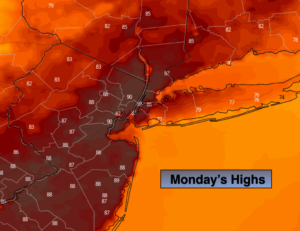
Today:
Partly sunny, hot and humid. Highs in the upper 80s. Cooler at the shore. Southwest winds at 10-15mph. A late day or evening shower is possible. Southwest winds at 10-15mph.
Tonight:
Mostly cloudy. Scattered showers. Lows in the mid 60s in urban areas, the upper 50s inland. West to Northwest winds at 5-10mph.
Tuesday:
Partly sunny. Not as warm. Highs in the mid 70s.
Wednesday:
Sunny. Highs in the upper 70s.
Thursday:
Partly sunny, warmer. Highs in the lower 80s.
Friday:
Sunny. Highs in the mid to upper 70s.