Synopsis:
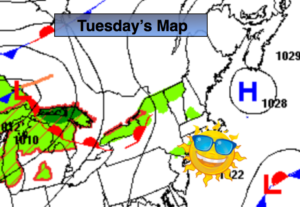
High pressure will be over the Northeast today. A mix of sun and clouds is expected with readings near the average high of 78º.
A warm front will move through tonight. Readings will be milder than recent nights.
Summertime warmth and humidity is back Wedensday. Temperatures will get into the 80s under partly sunny skies as the wind turns to the Southwest. Thursday will be warm, scattered showers are likely just about anytime as a cool front approaches, but much of the day will be dry.
Friday will be Fall-like with high pressure over New England giving us a cooler close to the week.
The weekend will be fairly decent. A spot shower is possible on Saturday otherwise a mix of sun and clouds is expected with comfortable temperatures.
Stay Tuned.
Keep it here for a no nonsense, no hype forecast.
Today:
Sun and clouds. Highs in the mid to upper 70s. Northeast to Southeast winds at 5-10mph.
Tonight:
Partly cloudy. Lows in the upper 60s in the City, the lower to mid 60s inland. South/Southwest wind at 5mph.
Wednesday:
Partly sunny, warmer and more humid. Highs in the mid 80s.
Thursday:
Hazy, warm and humid. Spotty showers and isolated storms. Highs in the mid 80s.
Friday:
Partly sunny, much cooler. Highs in the lower 70s.
Saturday:
Partly sunny. A spotty shower is possible. Highs in the mid to upper 70s.