Synopsis:
High pressure will build into the Northeast for the beginning of the week. A mix of sun and clouds is expected with cooler than normal readings (the average high is 78º).
A warm front will move through on Wednesday with Summertime temperatures returning. Thursday will be warm and humid. Scattered afternoon and evening showers and possible thunderstorms are likely by late day as a cool front approaches.
Friday will be Fall-like with high pressure over New England giving us a cooler close to the week.
Stay Tuned.
Keep it here for a no nonsense, no hype forecast.
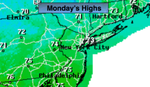
Today:
Sun and clouds. Cool. Highs in the lower 70s. Northeast to Southeast winds at 5-10mph.
Tonight:
Partly cloudy and cool. Lows in the lower 60s in the City, the mid 50s inland. Light East winds.
Tuesday:
Partly sunny. Highs in the mid 70s.
Wednesday:
Partly sunny, much warmer. Highs in the mid 80s.
Thursday:
Hazy, warm and humid. Chance of late day showers and storms. Highs in the mid 80s.
Friday:
Partly sunny, much cooler. Highs in the lower 70s.