Synopsis:
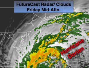
Hurricane Dorian will track up and off our coast on today and tonight. There is a chance of spotty rain mainly at the coast and over Long Island as the hurricane makes it’s closest approach but we shouldn’t experience Dorian’s wrath. Gusty winds are expected at the coast. Otherwise the day with be mostly cloudy with some peeks of sun. It’ll be several degrees cooler than the average high of the upper 70s.
The weekend at this time looks mainly sunny with seasonal readings and low humidity as high pressure noses in from the Great Lakes.
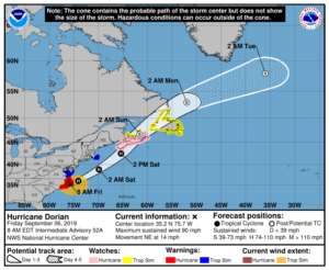
Category 1 Hurricane Dorian made a brief landfall this morning around Cape Hatteras, North Carolina. The hurricane as of this writing has 90mph sustained winds. The hurricane is moving Northeast and will move Northeast of the Outer Banks later today. These areas will experience the most impact from Dorian in the United States. Flooding rain, coastal tidal flooding and hurricane force wind gusts are expected for the Outer Banks. The storm will then move more rapidly Northeast and be well offshore New England by Saturday.
Stay Tuned.
Keep it here for a no nonsense, no hype forecast.
Today:
Clouds, some peeks of sun. Spotty rain is possible at the coast and over Long Island. Breezy and cool. Highs in the upper 60s to lower 70s. Northeast winds at 10-20mph. Winds will be stronger at the coast with gusts up to 30-40mph later in the day.
Tonight:
Spotty areas of rain, mainly at the coast, otherwise mostly cloudy. Cool. Lows around 60º in the City, the lower 50s inland. Northeast to North winds at 15-25mph with higher gusts at the coast.
Saturday:
Mostly sunny. Highs in the upper 70s.
Sunday:
Mostly sunny. Highs in the mid 70s.
Monday:
Mostly sunny. Highs in the mid 70s.
Tuesday:
Mostly sunny. Highs in the mid to upper 70s.