Synopsis:
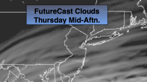
Today with feature filtered sunshine through high clouds. The cirrus clouds are from circulation of Hurricane Dorian to the South . It’ll be comfortable with readings near the seasonal levels of the upper 70s.
Hurricane Dorian should track up and off our coast on Friday and Friday night. There is a chance of some rain as the hurricane makes it’s closest approach but we shouldn’t experience severe conditions. The best chance of rain will be along the coast and over Long Island. Winds will be gusty at the coast. Please check back to JMW for the very latest for our area.
The weekend at this time looks mainly sunny with seasonal readings and low humidity.
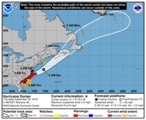
Category 3 Hurricane Dorian is just East of South Carolina coast with 115mph sustained winds as of this writing. The hurricane has made the turn to the North/Northeast and will parallel the coast just far enough to spare South Carolina of significant damage through the early afternoon hours.
The potential storm track continues a Northeast motion up and along the North Carolina coastline later today thorough Thursday night. Whether the hurricane skirts the beach or remains just offshore these areas will experience the most impact from Dorian in the United States. Flooding rain, coastal tidal flooding and hurricane force wind gusts are expected for parts of coastal North Carolina. The storm will then move more rapidly Northeast and be well offshore New England by Saturday. Stay Tuned.
Keep it here for a no nonsense, no hype forecast.
Today:
Sunshine filtered by high clouds, much cooler and less humid. Highs only in the mid 70s. Northeast winds at 5-10mph.
Tonight:
Mostly cloudy. Cool. Lows in the lower 60s in the City, the lower 50s inland. East/Northeast winds at 5-10mph.
Friday:
Cloudy. A period of rain and wind is possible, especially at the coast and to the East. Highs only around 70º.
Saturday:
Mostly sunny. Highs in the upper 70s.
Sunday:
Mostly sunny. Highs in the upper 70s.
Monday:
Partly sunny. Highs in the mid 70s.