Synopsis:
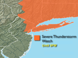
A Severe Thunderstorm Watch is in effect until 9PM for all of NYC, Northeastern NJ, Southern NY State, Long Island and Connecticut (1st map above). Keep an eye to the sky for threatening weather. Severe thunderstorms contain one of the following criteria: winds in excess of 58mph and or one inch hail. Torrential rain and frequent cloud to ground lightning will accompany the storms. A disturbance will work in from the West later today and this evening sparking the scattered thunderstorms.
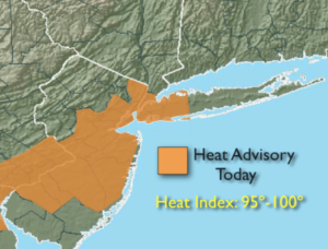
The Bermuda high will remained anchored off the US coast through tomorrow. This system will be responsible for the heat and humidity. A Heat Advisory is in effect for the NYC vicinity and Central and Southern NJ for today (2nd map above). Please take it slow outdoors and drink plenty of fluids.
Thursday will be the last day of the hot and humid conditions. A cool front is expected to move through Thursday night. Temperatures will once again be near 90º. Spotty storms are possible later in the day and during the evening as the front approaches.
Relief will arrive by Friday and the weekend looks spectuacular!
Stay cool!
Keep it here for a no nonsense, no hype forecast.
Today:
Hazy, hot and humid. Scattered PM storms. Highs in the 80s near 90º. South wind at 8-15mph.
Tonight:
A stray evening storm, otherwise partly cloudy, warm and muggy. Lows in the mid 70s in the City, the upper 60s elsewhere. Light Southwest winds.
Thursday:
Hazy, very warm and humid. Scattered PM Storms. Highs around 90º.
Friday:
Partly sunny, much cooler and less humid. Highs around 80º.
Saturday:
Sunny with low humidity. Highs around 80º.
Sunday:
Sunny with low humidity. Highs in the mid to upper 70s.