Synopsis:
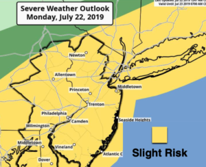
We are going to pay the price for relief from the heat today and tonight. A cool front will basically stall in the NYC vicinity today and tonight. This front has put an end to the heatwave but will be the focus mechanism for scattered severe thunderstorms and torrential rain. There is a slight risk of severe thunderstorms later today and early tonight. Severe thunderstorms contain at least one of the following criteria: winds in excess of 58mph and or one inch hail. Please keep an eye to the sky for threatening weather after 2PM.
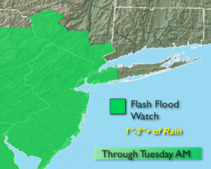
A Flash Flood Watch has been posted through Tuesday morning for the potential of 1-2″+ of rain. The best chance for areas of torrential rain will be later this afternoon through early Tuesday morning. Thunderstorms will be slow moving and will “train” over the same area causing the flooding concerns. If you encounter a flooded roadway-TURN AROUND-DON’T DROWN.
The front will linger in the morning on Tuesday with the heaviest rain pushing to the coast and out east. Late day sun is possible. True relief from the heat and humidity will arrive with highs only in the 70s!
Wednesday through Friday will be beauties with plenty of sunshine and low humidity.
Stay tuned.
Keep it here for a no nonsense, no hype forecast.
Today:
Clouds & sun, not as hot but still humid. Scattered showers and storms. Highs in the lower to mid 80s (readings could approach 90º Southwest of the City). Northeast winds at 5mph.
Tonight:
Areas of rain and thunderstorms. Some of the storms maybe severe early and the rain torrential. North winds at 5mph.
Tuesday:
Morning rain, otherwise remaining mostly cloudy. Much cooler and less humid. Highs in the mid 70s.
Wednesday:
Mostly sunny and comfortable. Highs in the lower to mid 80s.
Thursday:
Sunny. Low humidity. Highs in the mid 80s.
Friday:
Sunny. Highs in the mid to upper 80s.