Synopsis:
We are going to pay the price for relief from the heat in the form of thunderstorms. A cool front move into and through the region overnight. This front will put an end to the heatwave but will be the focus mechanism for scattered severe thunderstorms and torrential rain. A Severe Thunderstorm Watch is in effect until 10PM for the entire tri-state area. Severe thunderstorms contain at least one of the following criteria: winds in excess of 58mph and or one inch hail.
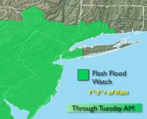
A Flash Flood Watch has been posted through Tuesday morning for the potential of 1-2″+ of rain. Thunderstorms will be slow moving and will “train” over the same area causing the flooding concerns. If you encounter a flooded roadway-TURN AROUND-DON’T DROWN.
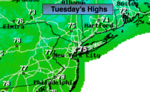
The front will linger in the morning on Tuesday with the heaviest rain pushing to the coast and out east. Late day sun is possible but the day will be dominated by clouds. True relief from the heat and humidity will arrive with highs only in the mid 70s. It will feel like a different season!
Wednesday through Saturday will be beauties with plenty of sunshine and low humidity to start as high pressure dominates the Eastern one third of the country.
Stay tuned.
Keep it here for a no nonsense, no hype forecast.
Tonight:
Areas of rain and thunderstorms. Some of the storms maybe severe early and the rain torrential. North winds at 5mph. Lows in the 60s throughout.
Tuesday:
Morning rain, otherwise remaining mostly cloudy. Much cooler and less humid. Highs in the mid 70s.
Wednesday:
Mostly sunny and comfortable. Highs in the lower 80s.
Thursday:
Sunny. Low humidity. Highs in the mid 80s.
Friday:
Sunny. Highs in the mid to upper 80s.
Saturday:
Sunny. Highs in the upper 80s.