Synopsis:
The weekend is looking fairly decent. High pressure will move off the coast for today. The flow around the high will become Southwest. Readings will rise to warm levels under mostly sunny skies.
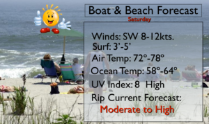
If you’re headed to the beach please use caution as there is a moderate to high risk of rip currents. A rip current is a power channel of water that moves away from the shoreline. If you get caught in a rip current remain calm. Swim parallel to the beach until you are out of the current, then swim back to shore. Always swim by guarded beaches.
For Father’s Day a weak front will approach the region. The day may start off cloudy but hazy sun is expected for the late morning into the mid-afternoon hours. It’ll be warm and more humid. Showers and scattered storms are possible later in the afternoon and evening. Father’s day will not be a washout. I am sticking to my outdoor plans, but keeping an eye to the sky after 2PM!
The threat of scattered showers and storms will continue through midweek as a stationary front gets hung up over the region. It won’t be raining constantly and the sun will shine from time to time.
Keep it here for a no nonsense, no hype forecast.
Saturday:
Mostly sunny, warm and becoming breezy. Highs in the lower 80s. Southwest winds increasing to 15-25mph.
Tonight:
Becoming mostly cloudy. Not as cool as last night. Lows in the mid to upper 60s in the City, the low 60s inland. Southwest winds diminishing to 5mph.
Father’s Day:
Clouds to start then becoming hazy, warm and humid. Scattered afternoon and evening storms are possible. Highs in the lower 80s.
Monday:
Hazy, warm and humid. Scattered afternoon storms are possible. Highs in the lower 80s.
Tuesday:
Hazy, warm and humid. Scattered afternoon storms are possible. Highs in the lower 80s.
Wednesday:
Hazy, warm and humid. Scattered afternoon storms are possible. Highs around 80º.