Synopsis:
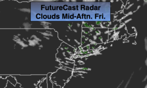
Today will feature a mix of sun and clouds as high pressure moves along the East coast. It will be breezy. A trough of low pressure will zip through during the late morning to mid afternoon hours. Spotty showers are possible with this feature. It won’t be a big deal.
The weekend is looking decent. The high will move off the coast for Saturday. The flow around the high will become Southwest. Readings will rise to warm levels under partly sunny skies
For Father’s Day a bubble humid air will move in. Hazy sun is expected and an afternoon scattered thunderstorm is possible. Not a washout by any stretch of the imagination.
The threat of scattered storms continues for Monday. Tuesday should be dry under a mix of sun and clouds.
Keep it here for a no nonsense, no hype forecast.
Today:
Partly sunny and breezy. A stray shower is possible by late morning into the mid afternoon. Highs in the mid 70s. West winds at 15-25mph with higher gusts.
Tonight:
Mostly clear and cool. Lows in the lower 60s in the City, the low 50s inland. Southwest winds diminishing to 5mph.
Saturday:
Partly sunny. Warm. Highs in the lower 80s.
Father’s Day:
Hazy, warm and humid. A spot afternoon storm is possible. Highs in the mid 80s.
Monday:
Hazy, warm and humid. A spot afternoon storm is possible. Highs in the mid 80s.
Tuesday:
Partly sunny. Highs in the lower 80s.