Synopsis:
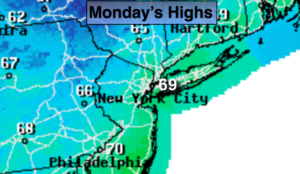
It won’t feel like June today as a refreshingly cool airmass works in from Canada. Skies will be mostly sunny with readings five to seven degrees below the average high of the mid 70s. A Monday forecast most will be smiling about!
Tonight will be crisp, and down right chilly in the suburbs. Lows will dip into the 40s away from the urban corridor.
Tuesday will be a gem as high pressure works overhead. Sunny and comfortable conditions are expected.
A Southwest flow will develop on Wednesday and Thursday as high pressure settles over the Southeast. This will result in readings once again at or above 80º. A spot shower can’t be ruled out.
Keep it here for a no nonsense, no hype forecast.
Today:
Mostly sunny, cooler and breezy. Highs in the upper 60s to lower 70s. Northwest wind at 10-20mph.
Tonight:
Clear and very cool. Lows in the lower 50s in the City, the 40s inland. Northwest wind diminishing to 5mph.
Tuesday:
Mostly sunny. Highs in the lower 70s.
Wednesday:
Partly sunny. Warmer. Stray late day shower. Highs around 80º.
Thursday:
Partly sunny. Warm. Stray late day shower. Highs in the lower 80s.
Friday:
Partly sunny. Highs in the mid to upper 70s.