Synopsis:
High pressure which originated in Canada will move over the area tonight. This will result in very chilly temperatures. Lows will dip into the 40s away from the urban corridor.
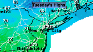
Tuesday will be a gem as high pressure remains in control. Sunny and comfortable conditions are expected.
A Southwest flow will develop on Wednesday and Thursday as high pressure settles over the Southeast. This will result in readings at or above 80º. A spot shower can’t be ruled out both day in the humid airmass.
A weak cool front will move through Thursday night this will lower the humidity and temperature for the end of the week and into the beginning of the weekend.
Keep it here for a no nonsense, no hype forecast.
Tonight:
Clear and very cool. Lows in the lower 50s in the City, the 40s inland. Northwest wind diminishing to 5mph.
Tuesday:
Mostly sunny. Highs in the lower 70s. Northwest to Southwest winds at 8-12mph.
Wednesday:
Partly sunny. Warmer. Stray late day shower. Highs around 80º.
Thursday:
Partly sunny. Warm and humid. Scattered showers possible just about any time. It will not be a washout. Highs in the lower 80s.
Friday:
Partly sunny. Highs upper 70s.
Saturday:
Mostly sunny. Highs upper 70s.