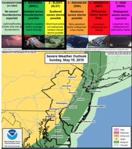
Synopsis:
A disturbance moving through the area early tonight will cause scattered showers and storms. Some of the storms inland may approach severe limits (map above).
Scattered showers and storms will diminish after midnight. It’ll be warm and more humid overnight.
Monday will be very warm due to a Southwest flow. Readings will get well into the 80s under a mix of sun and clouds. Spotty showers and storms are possible during the afternoon and evening. The passage of a cool front will bring the temperatures down to seasonal levels (lower 70s) Tuesday and Wednesday under mainly sunny skies.
The end of the week looks fairly decent with just above average temperatures.
Keep it here for a no nonsense, no hype forecast.
Stay tuned.
Tonight:
Scattered showers and storms. A few of the storms maybe severe inland. Becoming partly cloudy after midnight. Warm and more humid. Lows in the 60s. South to Southwest winds at 5-10mph.
Monday:
Hazy and warm. Spotty afternoon showers or storms. Highs in the lower to mid 80s.
Tuesday:
Mostly sunny. More seasonal. Highs in the lower 70s.
Wednesday:
Sunny. Highs in the lower 70s.
Thursday:
Patly sunny. Highs in the mid 70s.
Friday:
Patly sunny. Highs in the mid 70s.