Synopsis:
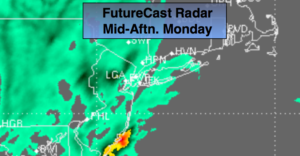
Round 2 of rain will affect the area today. Another low will develop just East of Delaware midday and move Northeast to South of Montauk Point by this evening. On and off rain will be with us today. One batch of rain will work through this morning. There looks to be a lull for a few hours. Another area of steadier and heavier rain will affect the entire area this afternoon. Additional rainfall amounts of a half inch to an inch is possible. Flooding is a concern where the rain amounts are the highest.
The rain will taper off this evening and skies will remain cloudy.
Spotty showers are expected Tuesday as the upper level low moves through.
Wednesday will be the best day out of the bunch. We’ll dry out under partly sunny skies.
The shower threat returns Thursday as a front swings through. We’ll dry out Friday as high pressure moves in.
Stay tuned.
Keep it here for a no nonsense, no hype forecast.
Today:
Morning spotty drizzle becoming a steadier and heavier rain. Chilly. Highs in the lower 50s. Northeast winds at 10-20mph.
Tonight:
Cloudy. Cold. Lows in the lower 40s. Northeast winds becoming North at 5-10mph.
Tuesday:
Mostly cloudy with scattered showers. Highs in the mid 50s.
Wednesday:
Partly sunny. Highs in the mid 60s.
Thursday:
Mostly cloudy with scattered showers. Highs in the upper 60s.
Friday:
Partly sunny. Highs in the upper 60s.