Synopsis:
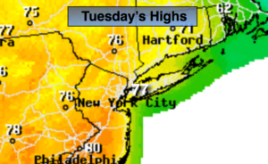
Today will be a complete turnaround from the last few days. It’ll be mainly sunny and warm as a weak ridge of high pressure influences our weather from the Southeast. Highs will be more then ten degrees above the average high of 64º.
A cool front will cross the region tonight with scattered showers.
Wednesday and Thursday will be two gems as high pressure dominates. Mainly sunny skies are expected. By Friday a cool front will approach. Showers are likely.
The weekend at this time looks decent.
Stay tuned.
Keep it here for a no nonsense, no hype forecast.
Today:
Mostly sunny. Warm. Highs in the mid to upper 70s. Northwest to South winds at 5-10mph.
Tonight:
Mostly cloudy with scattered showers. Lows in the mid 50s in the City, near 50º inland. Southeast to Northwest winds at 5-10mph.
Wednesday:
Mostly sunny. Highs around 70º.
Thursday:
Mostly sunny. Highs around 70º.
Friday:
Mostly cloudy with scattered showers. Highs in the mid 60s.
Saturday:
Partly sunny. Highs in the mid 60s.