Synopsis:
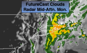
Low pressure will develop just off the coast today as the last push of the system that has been affecting our weather since Friday moves through. Any sun will give way to mostly cloudy skies. As the low moves up and of the coast scattered showers are likely this afternoon and evening. The best chance will be over Eastern sections and along the coast. In fact, Eastern Long Island and Connecticut looked to get into a band of steadier and heavier rain (FutureCast radar above).
The low will move off the New England coast tonight. Skies will clear.
Tuesday will be partly sunny and much warmer. The midweek period will feature tranquil conditions as high pressure dominates.
The nest chance of rain will be with a cool front working working in.
Keep it here for a no nonsense, no hype forecast.
Stay tuned.
Today:
Sun to clouds with afternoon showers possible. Heavier and steadier rain likely over Eastern sections. Highs in the 60s to near 70º. North winds at 5-10mph.
Tonight:
Any leftover showers or rain out East will end. Skies will become partly cloudy. Lows in the lower to mid 50s in the City, the upper 40s inland. North/Northwest wind at 5-10mph.
Tuesday:
Partly sunny. Warm. Highs in the mid to upper 70s.
Wednesday:
Partly sunny. Highs around 70º.
Thursday:
Partly sunny. Highs in the mid to upper 60s.
Friday:
Mostly cloudy with scattered showers. Highs in the mid 60s.