Synopsis:
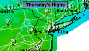
Temperatures will be near seasonal averages today as high pressure builds over the Northeast. A mix of sun and clouds is expected. The average high temperature is in the upper 50s.
The high will move off the coast on Friday. Clouds will dominate the sky as a front approaches. The day looks to be dry, although areas of fog and spotty drizzle can’t be ruled out in the morning. Showers are likely Friday night.
The front will get hung up just offshore for the weekend. A few morning showers are possible Saturday, but enough dry air should work in from the West to burn off the clouds by afternoon (meaning the sun should shine). It’ll be mild.
On Sunday a storm will develop over the Southern states and ride up the Appalachians. The day will be mostly cloudy. Showers are likely by afternoon.
Keep it here for a no nonsense, no hype forecast.
Today:
Sun and clouds. Highs in the mid to 50s. North to Southeast winds at 5-10mph.
Tonight:
Mostly cloudy. Lows around 40º-45º. Southeast winds diminishing to 5mph.
Friday:
Mostly cloudy. Areas of morning fog and spotty drizzle. Showers are possible by evening. Highs in the lower 60s.
Saturday:
A few morning showers, otherwise skies should become partly sunny by afternoon. Milder. Highs around 70º.
Sunday:
Mostly cloudy. Showers are likely by afternoon. Highs in the lower 60s.
Monday:
Rain likely during the morning. Remaining mostly cloudy. Highs in the mid 60s.