Synopsis:
High pressure will move over the area today. It will be another gem. Abundant sunshine and mild readings are expected. Temperatures will be nearly ten degrees above the average of 57º.
A warm front will approach tonight with rain developing around midnight.
Monday and Tuesday will be changeable days as weak systems rapidly move through the region. Morning showers are expected Monday as the warm front moves through. The clouds will break for some sunshine. It will be warm with highs reaching the 70s. Tuesday will start off with sun but clouds will roll in. A spot shower is possible later in the day.
Temperatures will return to more seasonal averages by mid to late week with dry conditions.
Keep it here for a no nonsense, no hype forecast.
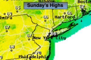
Sunday:
Mostly sunny. Highs in the mid 60s. Northeast to South winds at 5-10mph.
Tonight:
Cloudy with rain developing toward midnight. Mild. Lows in the 50s throughout. South to Southeast wind at 5-10mph.
Monday:
Morning showers, becoming partly sunny. Warm. Highs in the lower 70s.
Tuesday:
Clouds and sun. Scattered PM shower. Highs in the mid 60s.
Wednesday:
Mostly sunny. Cooler. Highs in the upper 50s.
Thursday:
Sunny. Highs in the mid to upper 50s.