Synopsis:
A cool front will work through today with scattered showers. The showers will move through from mid morning through early afternoon. The sun will return later in the day. It’ll become windy behind the front.
Tonight will be clear, windy and cold with lows within a few degrees of freezing.
The majority of the workweek looks bright as high pressure works in from the Great Lakes. Readings will start off below average then rise to above average by mid to late week.
Keep it here for a no nonsense, no hype forecast.
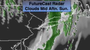
Today:
Mostly cloudy and mild. Scattered showers will dot the region from mid-morning to early afternoon. The sun will return later in the day. Highs in the mid to upper 50s. Southwest to Northwest winds increasing to 10-20mph with higher gusts by late day.
Tonight:
Clear, windy and much colder. Lows in the lower to mid 30s in the City, around 30º inland. Northwest winds at 15-25mph with gusts to 30mph.
Monday:
Mostly sunny, breezy and cooler. Highs in the upper 40s.
Tuesday:
Mostly sunny and cool. Highs around 50º.
Wednesday:
Mostly sunny. More seasonal. Highs in the mid 50s to around 60º.
Thursday:
Mostly sunny. Highs around 60º.