Synopsis:
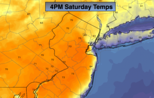
High pressure off the Southeast coast will result in a South to Southeast flow today. It’ll all depend on your location as to your temperature. Inland readings will be warm-topping 70º. Along the coast temperatures will remain in the 50s and 60s. The cold Atlantic will have a big influence in coastal communities with the wind blowing off the water. Clouds will give way to some sunshine. The better half of the weekend will definitely be today.
On Sunday a cool front will work through with scattered showers. It won’t be raining all the time. There will be some sun later in the afternoon.
The beginning of the workweek looks bright and cool as high pressure works in from the Great Lakes.
Keep it here for a no nonsense, no hype forecast.
Today:
Clouds will give way to some sunshine. Highs in the lower 70s inland. Much cooler over Long Island and coastal communities with readings remaining in the 50s and 60s. South to Southeast winds at 8-15mph.
Tonight:
Partly cloudy and mild. Lows in the lower to mid 50s in the City, the 40s to lower 50s inland. Southeast wind at 5-10mph.
Sunday:
Mostly cloudy and mild. Scattered showers. The timing for the showers will be from mid-morning to early afternoon. The sun will return later in the day. Highs in the mid to upper 50s.
Monday:
Mostly sunny and cooler. Highs around 50º.
Tuesday:
Mostly sunny and cool. Highs around 50º.
Wednesday:
Partly sunny. More seasonal. Highs in the mid 50s.