Synopsis:
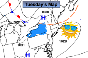
The sun will be the dominate feature through Wednesday as high pressure settles over the East coast.
Spring arrives Wednesday at 5:58pm EDT. This is the exact time when the sun’s direct rays crossed North of the equator.
On Thursday a weak front will approach the area. At the same time a storm will develop off the Mid-Atlantic coast. Showers are likely Thursday and Thursday night.
The storm will bomb off the New England coast on Friday as it moves out to sea. Winds will increase dramatically during the day and become strong. A few spotty showers are possible with the upper level low moving through the region.
At this time the weekend looks precipitation free. It’ll be blustery and chilly on Saturday. Sunday will be the better half with much milder readings. Both days will feature sun.
Keep it here for a no nonsense, no hype forecast.
Today:
Sunny. Highs in the mid 40s. Northwest to Southwest winds at 5-10mph.
Tonight:
Clear. Lows in the mid 30s in the City, the 20s inland. Southwest under 5mph.
Wednesday:
Sunny. Highs in the lower 50s.
Thursday:
Mostly cloudy with a chance of showers. Highs around 50º.
Friday:
Partly sunny and becoming windy. Spotty showers are possible during the afternoon. Highs near 50º. Temperatures will fall during the afternoon.
Saturday:
Partly sunny, windy and chilly. Highs in the mid 40s.