Synopsis:
An early morning mix well North will change over to rain. Rain will fall elsewhere as a warm front pushes toward the area. The rain looks to taper off by midday but clouds will hang tough through the afternoon.
Tranquil conditions are expected to the beginning of the workweek. Readings will be mild on Monday with temperatures dropping back to more seasonal readings for mid March through midweek as high pressure moves in. Several days of sunshine is on the way.
The next chance of showers won’t arrive until Friday.
Keep it here for a no nonsense, no hype forecast.
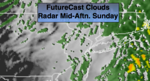
Today:
Early mix well North to rain. The rain will taper off around midday. Remaining clouds during the afternoon. Highs in the mid to upper 40s. East to Southwest winds at 5-10mph.
Tonight:
Becoming partly cloudy. Lows around 40º in the City, the 30s inland. West winds at 8-12 mph.
Monday:
Partly sunny. Mild. Highs around 50º.
Tuesday:
Partly sunny, cooler. Highs in the lower 40s.
Wednesday:
Sunny. Highs in the mid 40s.
Thursday:
Mostly sunny. Mild. Highs in the mid 50s.