Synopsis:
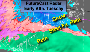
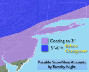
Low pressure will be moving through the Eastern states today. Arctic air will be to our North, but like so many times this season low pressure will move to our West allowing mild air to work up from the South. A mix of snow and sleet will develop this morning. The mix will to go over to rain over central NJ toward midday. For the NYC vicinity and inland areas, snow will transition to sleet and freezing rain (first map above) during the late morning and through the afternoon. It all depends on your location as to the specific type of frozen precipitation you’ll receive. There maybe a prolonged period of sleet. Treacherous travel is expected on untreated surfaces. Potential snow/sleet amounts are above.
Rain is likely with a secondary storm hugging our coastline. Well inland there will be pockets of freezing rain. One to two inches of liquid equivalent precipitation is likely.
Tranquil and mild conditions are expected Wednesday and Thursday. Another storm will approach the region Friday and Saturday. Many of the computer models now have the storm missing the region. We’ll fine tune the weekend forecast over the next couple of days.
You know where to find a no hype, no nonsense forecast.
Stay tuned.
Today:
Snow/mix developing this morning to rain along the coast. Snow to sleet and freezing rain inland. Highs in the mid to upper 30s, closer to freezing well inland. East to Northeast winds at 15-25mph with gusts to 30mph at the coast.
Tonight:
Rain, possibly heavy at times along the coast. Freezing rain possible well inland (serious icing is possible). Lows in the 30s throughout. Northeast winds becoming West at 10-20mph.
Wednesday:
Partly sunny. Highs in the mid 40s.
Thursday:
Mostly sunny, mild. Highs in the mid 40s.
Friday:
Early sun giving way to clouds and late day showers. Mild. Highs around 50º.
Saturday:
Chance of rain. Highs in the mid 40s.