Synopsis:
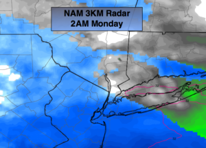
A period of light snow or flurries is possible tonight with a weak disturbance rapidly moving through. Many areas North of the City won’t see a flake (FutureCast NAM radar above). A dusting to a coating of snow is possible South of the City.
Monday will be mostly cloudy an another high pressure system influences our weather from Eastern Canada.
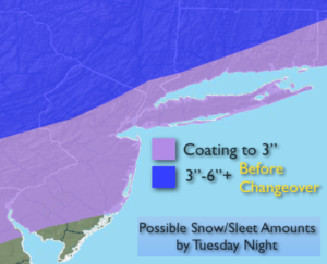
A complex area of low pressure moving through the Eastern states Tuesday and Wednesday. Arctic air will be to our North, but like so many times this season low pressure will move to our West allowing mild air to work up from the South. The potential is there for a quick hit of snow late Monday night and Tuesday morning. The snow looks to go over to rain during the morning along the coast. Inland, snow will transition to sleet and freezing rain. There maybe a prolonged period of sleet. The first stab at possible snow/sleet amounts are above. These amounts will change as we get closer to the event.
Heavy rain is likely Tuesday night with a secondary storm moving along our coast. One to two inches of liquid equivalent precipitation is likely. Yes, another moisture laden storm is on the way.
Tranquil and mild conditions are expected Wednesday and Thursday. Another storm will approach the region Friday and Saturday.
You know where to find a no hype, no nonsense forecast.
Stay tuned.
Tonight:
Mostly cloudy North. Light snow or flurries from the NYC vicinity and to the South. Lows in the upper 20s in the City, the teens inland. Southwest to North winds at 5mph.
Monday:
Mostly cloudy. Highs in the mid to upper 30s. Northeast winds at 5-10mph.
Tuesday:
Snow to rain along the coast. Snow to sleet and freezing rain inland. Highs in the mid to upper 30s, closer to freezing well inland.
Wednesday:
Partly sunny. Highs in the mid 40s.
Thursday:
Partly sunny, mild. Highs in the mid 40s.
Friday:
Early sun giving way to clouds and late day showers. Mild. Highs around 50º.