Synopsis:
The storm that gave the area between 1″-2.5″ of rain is moving into New England this evening. The rain will taper off later this afternoon and early evening. The runoff from the deluge will result in ponding of water on streets and highways. Streams and rivers are near bankfull and some waterways are flooding . If you encounter a flooded roadway- TURN AROUND, DON’T DROWN.
Our January thaw will come to an end. It’ll turn more seasonal on Friday as we dry out and get to see some sunshine. The weekend will be cold under a mix of sun and clouds as high pressure dominates. There are signs in the long range (Tuesday-Wednesday) that a storm may develop with a deep trough in the East. Where it develops along that trough and how it affects are weather remains to be seen, but at this time it appears weak until it passes to our North. At this time rain and snow showers are in the forecast for later Tuesday.
You know where to find a no hype, no nonsense forecast.
Stay tuned.
Tonight:
Rain ending all areas by this evening. Becoming partly cloudy and colder. Lows around 30º in the City, the 20s elsewhere. Winds West/Northwest at 10-15mph.
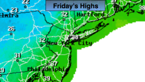
Friday:
Partly sunny and seasonal. Highs in the mid to upper 30s. West to Northwest winds at 15-25mph.
Saturday:
Partly sunny and cold. Highs around 30º.
Sunday:
Clouds and sun. Highs in the mid 30s.
Monday:
Partly sunny and cold. Highs in the lower to mid 30s.
Tuesday:
Sun giving way to thickening clouds. Rain or snow showers are possible later in the day. Highs around 40º.