Synopsis:
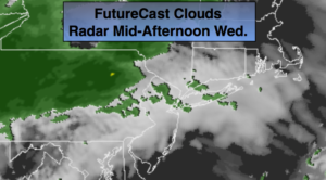
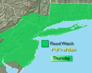
A January thaw will be with us through tomorrow. A Southerly wind will bring up milder air, but we’ll have to pay a bit of a price with wet weather moving in. A few glimpses of sunshine will give way to thinking clouds today. A front will move toward the area from the West increasing the threat of spotty showers later in the day (much of the day will be dry). A low will develop along that front over the Virginia Piedmont tonight and Thursday. This will cause the rain to become steadier and heavier. A Flood Watch has been posted for Thursday. One to two inches of rain is possible. The ground is saturated and frozen, this will cause the water to run off immediately resulting in possible flooding. Highs today will be in the mid 40s. By Thursday readings will reach into the 50s.
It’ll turn more seasonal on Friday as we dry out. The weekend will be cold under a mix of sun and clouds as high pressure dominates. There are signs in the long range (Mon-Tuesday) that a storm may develop with a deep trough in the East. Where it develops along that trough and how it affects are weather remains to be seen.
You know where to find a no hype, no nonsense forecast.
Stay tuned.
Today:
Mostly cloudy and much milder. Chance of spotty afternoon showers. Highs in the mid 40s. Southwest winds at 5-10mph.
Tonight:
Spotty light rain becoming steady and heavier late. Mild. Temperatures will remain steady in the 40s throughout. Southwest wind at 5-10mph with gusts up to 20mph late.
Thursday:
Rain. Mild. The rain will end by early afternoon. The sun may return later in the day. Highs in the lower 50s.
Friday:
Partly sunny and seasonal. Highs in the mid 30s.
Saturday:
Partly sunny and cold. Highs around freezing.
Sunday:
Partly sunny and cold. Highs in the lower to mid 30s.