Synopsis:
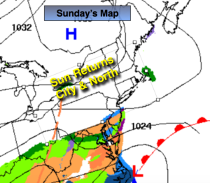
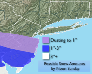
There will be areas of light snow and flurries from the NYC vicinity and to the South this morning. The steadiest and heaviest snow will be over Southern NJ. Areas to the North of the City will not see any snow. Southern NJ will be the jackpot zone for snow. The possible snow amounts are above. The sun will return later Sunday for most areas with the exception of Southern NJ where it may snow the majority of the day.
The workweek will be bright with moderating temperatures through Wednesday. Colder air will work in late week.
There will be a low on the map next weekend. How it interacts with Arctic air coming in from Canada is anyone’s guess at this point. PLEASE don’t listen to any FAKE WEATHER NEWS about a snowstorm this far out in the game. It’s pure hype this far out.
You know where to find a no hype, no nonsense forecast.
Stay tuned.
Today:
Areas of light snow or snow showers in the morning from the City and to the South, otherwise clouds will give way to some sun. The exception will be Southern NJ where snow may fall the majority of the day. Highs in the mid 30s. Northeast winds at 8-12mph.
Tonight:
Partly cloudy. Lows in the 20s thorughout. Northeast winds at 8-15mph.
Monday:
Partly sunny. Highs in the mid 30s.
Tuesday:
Sunny. Highs around 40º.
Wednesday:
Partly sunny. Highs in the lower 40s.
Thursday:
Sunny and colder. Highs in the lower to mid 30s.