Synopsis:
Low pressure moving from the Great Lakes into Eastern Canada today will bring up ample moisture and mild readings from the South. Yet again we’ll be dealing with rain and not snow, as this is a warm storm track.
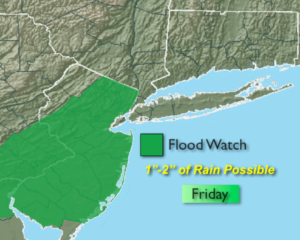
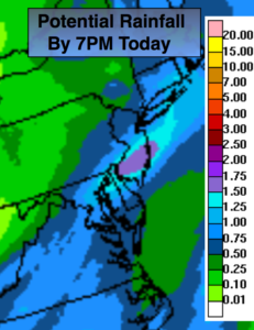
Periods of rain with some local downpours is expected today. Most areas will receive close to an inch of rain with less to the North of the City and more to the South (map above). A Flood Watch is in effect for much of NJ through Friday. The ground is saturated and streams and rivers are running high. If you encounter a flooded roadway, TURN AROUND, DON’T DROWN. The rain will taper off during the afternoon from Northwest to Southeast. It’ll be balmy with highs in the mid to upper 50s.
The weekend will start off mild on Saturday. It’ll become much colder on Sunday as the flow will be from Canada. The sun should dominate both days.
On New Year’s Eve another storm will take a similar track to Friday’s system. Yep, more rain on the way. At the stroke of midnight there’s a decent chance of rain but it looks to be mild. January 1st won’t feel like the season as the mild temperatures will stick around.
You know where to find a no hype, no nonsense forecast.
Stay tuned.
Today:
On an off rain. Local downpours. The rain will taper off during the afternoon. Balmy. Highs in the mid to upper 50s. Southeast to Southwest winds at 8-15mph.
Tonight:
Mostly cloudy. Lows will be much higher than the average high for the day! Readings will be in the upper 40s in the City, near 40º inland. The average high is 40º. Southwest to West winds at 5-10mph.
Saturday:
Partly sunny. Mild. Highs in the lower 50s.
Sunday:
Mostly cloudy and much colder. Highs in the upper 30s.
New Year’s Eve:
Mostly cloudy with rain developing. Mild. Highs reaching into the 50s by evening.
New Year’s Day:
Partly sunny. Mild. Highs in the lower 50s.
Keep it here for a no nonsense, no hype forecast.