Synopsis:
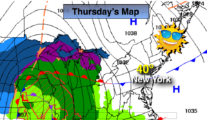
High pressure will dominate through today with tranquil and bright conditions. Readings will be near the average high of 40º.
The next chance of precipitation comes along tonight into Friday. The map above shows the low approaching the Great Lakes this afternoon. It will be too warm for snow-rain is expected at this time as the storm will ride to our West. The rain will develop tonight around or just after midnight. On and off rain is expected Friday with some local downpours. An inch of rainfall is possible.
The weekend will start off mild on Saturday. It’ll become much colder on Sunday as the flow will be from Canada. The sun should dominate both days.
On New Year’s Eve a weak low may skirt the region to our South. Showers are possible at this time. You know where to find a no hype, no nonsense forecast.
Stay tuned.
Today:
Mostly sunny. Highs around 40. Northwest to Southeast winds at 5mph.
Tonight:
Rain developing around midnight. A mix possible well inland. Lows tonight will rise through the 30s to around 40º in the City, the 30s inland. Southeast winds at 5mph.
Friday:
On an off rain. Mild. Highs in the mid to upper 50s.
Saturday:
Partly sunny. Mild. Highs in the lower 50s.
Sunday:
Mostly cloudy and much colder. Highs in the 30s.
New Year’s Eve:
Mostly cloudy with showers possible. Highs around 40º.
Keep it here for a no nonsense, no hype forecast.