Synopsis:
The storm over the Western Carolinas this morning will move North up the spine of the Appalachians by tonight. This is a mild scenario meaning rain and not snow. Ironically, today is the first day of Winter. The Solstice occurs at 5:23EST. It’ll won’t feel anything like Winter as readings will soar into the lower 60s!
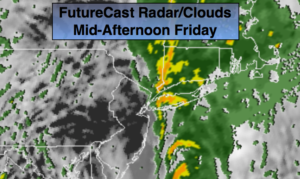
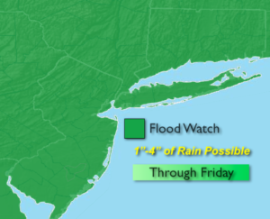
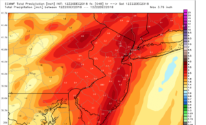
The storm will bring up copious amounts of moisture from the tropics. The rain will be heavy at times through this morning and into the Early afternoon. A Flood Watch has been issued for the entire tri-state area. One to four inches of rain is possible (last map is the European model showing total rainfall amounts). We do not need any more rain. River and streams are running high and the ground is saturated. Flooding will be a concern. If you encounter a flooded roadway, TURN AROUND, DON’T DROWN. The rain will taper off from West to East during the afternoon hours (First map above shows this).
Winds will be strong along the coast this morning, possibly gusting up to 50mph. Weak rooted trees may come down and isolated power outages are possible.
A Coastal Flood Warning is up much of the tri-state coastline for the likelihood of tidal flooding around the times of high tide this Morning. Tides will be 2-3 feet above normal.
The storm will depart later today and we’ll dry out this weekend. A mix of sun and clouds is expected. Temperatures will be in the 40s.
The chances of a white Christmas are slim to none. A few snow showers are possible Christmas Eve morning but it shouldn’t be enough to cover the ground for a White Christmas Day.
You know where to find a no hype, no nonsense forecast.
Stay tuned.
Today:
Periods of rain, possibly heavy at times. Balmy. Windy in the morning. Highs in the upper 50s to lower 60s. The rain will taper off during the afternoon from West to East. Winds South to Southeast at 15-30mph with gusts to 50mph especially along the coast in the morning. Winds will diminish to 10-20mph during the afternoon.
Tonight:
Mostly cloudy with isolated showers. Mild with lows in the 40s throughout. South winds becoming West to Southwest at 10-15mph.
Saturday:
Partly sunny.Windy. Highs around 50º.
Sunday:
Mostly sunny. Highs in the lower 40s.
Christmas Eve:
Chance of morning snow showers, otherwise partly sunny. Highs in the lower 40s.
Christmas Day:
Sun and clouds. Seasonal. Highs around 40º.
Keep it here for a no nonsense, no hype forecast.