Synopsis:
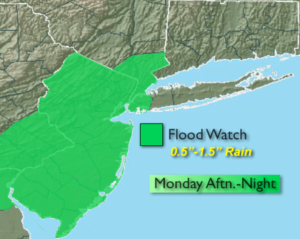
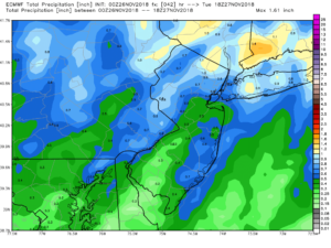
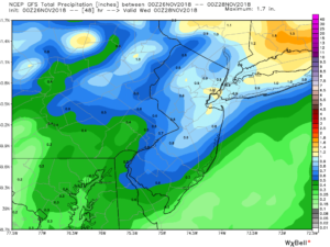
A low over the Eastern Great lakes will spawn a secondary low over Washington, DC today. This low will move over the area by evening. Rain will develop from mid-morning to early afternoon from Southwest to Northeast. There could be a period of heavy rain later in the day just in time for the PM commute. Since most area rivers are near bankfull and the ground is complete saturated any additional heavy rain will cause another round of flooding issues. For this reason a Flood Watch has been posted for much of the tri-state area. The second and third maps above are the European and GFS models respectively. Both show between 0.5″ and 1.5″ of rainfall by midnight tonight. The heaviest rain looks to fall North and East of the City. Coastal flooding is possible at times of high tide this afternoon and tonight for Long Island Sound.
We’ll get to dry out fo the rest of the week. It’ll be storm-free and chilly as a persistent dry Northwest wind takes hold due to an strong upper level low over the Northeast and Eastern Canada. Readings will be several degrees below the average high of 50º.
You know where to find a no hype, no nonsense forecast.
Stay tuned.
Today:
Cloudy. Rain developing by late morning or midday. The rain could be heavy at times late. Highs around 50º. East winds increasing to 10-20mph during the afternoon with gusts 30mph-40mph at the coast by late day.
Tonight:
Rain tapering off later in the evening. Becoming partly cloudy late. Lows in the lower 40s in the City, the 30s inland. East to West winds at 10-20mph.
Tuesday:
Partly sunny, breezy and cooler. Highs in the mid 40s.
Wednesday:
Partly sunny, windy and colder. Highs around 40º.
Thursday:
Partly sunny and breezy. Highs in the lower 40s.
Friday:
Partly sunny. Highs in the lower to mid 40s.
Keep it here for a no nonsense, no hype forecast.