Synopsis:
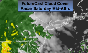
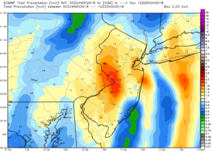
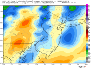
A low will trek out of the Southern states and toward the area later today. Clouds will thicken this morning. Scattered showers will develop from mid-afternoon on. The small, but potent storm looks to give the area a punch at night as it skirts the coastline. Most areas will receive a period of heavy rain. Above, in order, are the European and GFS rainfall totals. One to two inches of rain is possible. These amounts could cause flooding of streams, creeks and smaller rivers. Highway and street flooding is also possible.
The storm will move offshore early Sunday morning. Any predawn rain will end out East, otherwise skies will be partly sunny. The weather will cooperage for return home from the holiday weekend. Temperature will be seasonal-in the lower 50s.
Another low will move up the Atlantic Piedmont on Monday resulting in another round of rain.
The rest of the week will be storm-free and chilly.
You know where to find a no hype, no nonsense forecast.
Stay tuned.
Today:
Thickening clouds. Showers are likely by mid-afternoon. Much milder. Highs around 50º. Winds becoming East at 5-10mph.
Tonight:
A period of steady and heavy rain. Breezy. Gusty winds at the coast. Lows in the 40s in the City, the 30s inland. East to Northwest winds at 15-25mph with gust to 35mph at the coast.
Sunday:
Partly sunny and mild. Highs in the lower to mid 50s.
Monday:
Periods of rain. Highs around 50º.
Tuesday:
Partly sunny, cooler. Highs in the mid 40s.
Wednesday:
Partly sunny, colder. Highs around 40º.
Keep it here for a no nonsense, no hype forecast.