Synopsis:
I can’t remember a time when readings were in the single digits and teens in November. That’s what occurred this morning! Arctic high pressure sat right over the tri-state area. The record low for the date for Central Park is 14º. We missed it by one degree as the temperatures dipped to 15º.
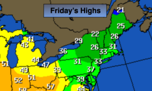
Black Friday will be cold and sunny skies as the mammoth high moves off the coast. Temperatures will touch the freezing mark.
A low will trek out of the Southern states and toward the area later Saturday. Sun will give way to clouds. Rain is likely Saturday afternoon and night. Sunday now l0oks to be dry under partly sunny skies as many travel home from their destination. Readings will be mild both days reaching the lower to mid 50s.
Another round of rain will occur on Monday.
You know where to find a no hype, no nonsense forecast.
Stay tuned.
Today:
Mostly sunny and cold. Highs around freezing. Winds becoming South at 5mph.
Tonight:
Clear to partly cloudy. Not as cold as last night. Readings will remain steady in urban areas, hovering around freezing. Inland temperatures will plummet to the teens and 20s and then rise slowly in the wee hours of the morning. Southwest winds at 5mph.
Saturday:
Any morning sun will give way to afternoon rain. Much milder. Highs around 50º.
Sunday:
Partly sunny and mild. Highs in the mid 50s.
Monday:
Periods of rain. Highs around 50º.
Tuesday:
Partly sunny, colder. Highs in the mid 40s.
Keep it here for a no nonsense, no hype forecast.