Synopsis:
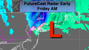
As the upper low moves over the area early this morning the last round of wet snow/sleet and rain will work through. An additional coating of snow or sleet is possible inland as this feature moves rapidly by. Winds will be strong this morning as they back around to the Northwest gusts to 45mph are possible. The the sun will return later in the morning as the storm moves up the coast and temperatures will rebound into the 40s. Snowmelt for sure. Winds will diminish later this afternoon.
Tonight will be mostly clear a refreeze of snow and slush will occur inland as readings will be below freezing. In urban areas readings will remain above freezing.
High pressure will dominate this weekend. It’ll be tranquil with temperatures below the average of 53.
The weekend will be chilly with a decent amount of sunshine.
No major storms are on the horizon as we head into Thanksgiving week.
You know where to find a no hype, no nonsense forecast.
Stay tuned.
A side note: The snow amounts yesterday were a BUST on my end. The cold air was stubborn to displace, especially in the city and closer to the coast, hence the higher amounts. Also, this was the most snow that fell for a day in NYC in over a CENTURY in November. You have to go back to November 29, 1880 where 9″ fell in NYC. Amazing.
Today:
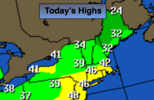
A quick shot of early morning rain/wet snow or sleet. otherwise the sun will make an appearance. Highs in the mid 40s. Northwest to West winds 15-30mph with gusts to 45mph at the coast in the morning diminishing to 10-15mph by afternoon.
Tonight:
Becoming mostly clear. Lows in the mid 30s in the City, the upper 20s inland. West winds at 5-10mph.
Saturday:
Mostly sunny and chilly. Highs in the upper 40s.
Sunday:
Mostly sunny and chilly. Highs in the mid 40s.
Monday:
A mix of sun and clouds. Flurries are possible. Highs in the lower 40s.
Tuesday:
Partly sunny and colder. Highs around 40º.
Keep it here for a no nonsense, no hype forecast.