Synopsis:
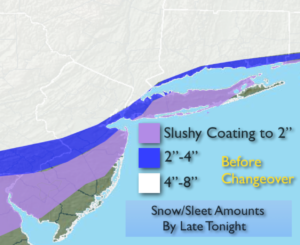
The latest analysis reveals that the cold air was stubborn to displace, hence the BUST in the snow amount forecast. The snow and sleet amounts were much higher than expected (map above). Please use caution while driving.
Tonight the precipitation will become lighter. Most areas will go over to rain with some freezing rain well inland. Winds will be an issue, especially by the coast. A Wind advisory is in effect for Monmouth and Ocean counties and coastal Connecticut for Northeast winds gusting to 45mph. A High Wind Warning is in effect for Eastern Suffolk County for winds gusts of 60mph. The storm will hug the coast overnight.
As the upper low moves over the area early Friday morning a quick shot of rain and or wet snow is possible. The the sun will return later in the morning as the storm moves up the coast.
The weekend will be chilly with a decent amount of sunshine.
You know where to find a no hype, no nonsense forecast.
Stay tuned.
Tonight:
Frozen precipitation will go over to rain with the exception of far Northwestern regions where freezing rain is likely. Lows in the 30s throughout. Northeast winds at 15-30mp with gusts to 45mph at the coast. Gusts up to 60mph over Eastern Long Island.
Friday:
A quick shot of early morning rain or wet snow. otherwise the sun will make an appearance. Highs in the mid 40s. Northwest to West winds 15-30mph in the morning diminishing to 10-15mph by afternoon.
Saturday:
Mostly sunny and chilly. Highs in the upper 40s.
Sunday:
Mostly sunny and chilly. Highs in the mid 40s.
Monday:
A mix of sun and clouds. Flurries are possible. Highs in the lower 40s.
Tuesday:
Partly sunny and colder. Highs around 40º.
Keep it here for a no nonsense, no hype forecast.