Synopsis:
It will be the tale of two seasons this weekend. Spotty showers will move off the coast early this morning as a warm front moves through. Skies will become partly sunny. Temperatures will rise into the mid 60s- a Spring feel. The average high is 62º. It’ll feel nice after the cold snap we’ve experienced.
Another significant cold front will move our way tonight with scattered showers late and gusty winds. Sunday will be most likely the coldest day of the season so far with a cold wind- a Winter feel. At least it won’t be raining.
It looks like Autumn wants to stick around into the workweek. Fair cool conditions are expected.
You know where to find a no hype, no nonsense forecast.
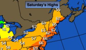
Today:
Spotty early morning showers East, otherwise, partly sunny. Milder. Highs in the mid 60s. Southwest to West winds at 10-20mph.
Tonight:
Becoming mostly cloudy with scattered showers late. Winds will also pick up after midnight. Lows in the lower to mid 40s in the City, the upper 30s inland. West to Northwest winds increasing to 15-25mph late.
Sunday:
Partly sunny, windy and cold. Highs in the upper 40s.
Monday:
Mostly sunny and cool. Highs in the mid 50s.
Tuesday:
Partly sunny. Highs near 60º.
Wednesday:
Partly sunny. Highs in the mid 50s.
Keep it here for a no nonsense, no hype forecast.