Synopsis:
After the morning freeze and frost just outside the City, temperatures will rise to just below seasonal averages (the lower 60s) today. The sun will rule the sky as high pressure dominates.
Spotty showers are possible late tonight and Saturday morning as a warm front moves through. Skies will become partly sunny Saturday. Temperatures will rise into the 60s. It’ll feel nice after the cold snap we’ve experienced.
Another significant cold front will move our way Saturday night. Sunday will be most likely the coldest day of the season so far with gusty winds. At least it won’t be raining.
It looks like Autumn wants to stick around into the beginning of the workweek. Fair cool conditions are expected.
You know where to find a no hype, no nonsense forecast.
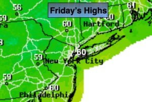
Today:
Mostly sunny. Highs in the upper 50s to around 60º. Southwest winds at 10-15mph.
Tonight:
Partly cloudy early, increasing clouds late with a chance of showers. Not as cold as recent nights. Lows in the lower 50s in the City, the 40s inland. Southwest winds at 8-12mph.
Saturday:
Spotty morning showers, otherwise, partly sunny. Milder. Highs in the lower to mid 60s.
Sunday:
Partly sunny, windy and cold. Highs in the upper 40s.
Monday:
Mostly sunny and very cool. Highs in the lower 50s.
Tuesday:
Partly sunny. Highs near 60º.
Keep it here for a no nonsense, no hype forecast.