Synopsis:
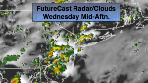
Grey, damp conditions will continue through today as a light flow off the ocean and trough of low pressure remains over the area. Scattered showers and storms are possible just about anytime. There will be areas of drizzle and fog through the morning hours. Humidity levels will be high.
For Thursday into Friday high pressure over New England should bring somewhat drier air into our area. A mix of sun and clouds is expected. Will some moisture in the form of scattered showers working in off the ocean from Florence’s circulation occur? It’s a possibility. That will most likely be the only affect from the storm, if it occurs. Rough surf and dangerous rip currents will definitely be an issue.
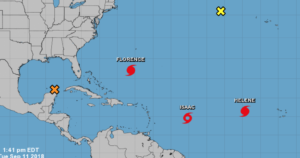
There are currently three storms in the Atlantic. Hurricane Florence, Tropical Storm Issac and Hurricane Helene (2nd map above).
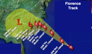
Hurricane Florence is in the Atlantic between Bermuda and the Bahamas. Florence as of this writing is a Category 4 hurricane with winds of over 130mph. The models are in very good agreement that the hurricane will move close to the Carolina’s later Thursday into Friday morning. Pinpoint location of possible landfall is a huge question that will need some time to answer. We’ll continue to track. While we track, please don’t concentrate on the exact line (map above), but rather the yellow cone of uncertainty (map above). The storm looks to stall and spin for possibly a couple of days after this time frame as steering currents in the upper atmosphere are weak to none. Will it be inland or just off the coast? Where this happens is still a important question that needs to be answered. Extreme rainfall amounts are possible where Florence possibly stalls. A major flooding event is possible. You know where to find a no hype, no nonsense forecast.
Stay tuned.
Today:
Areas of morning fog and drizzle, otherwise mainly cloudy, warm and humid. Spotty showers and storms are possible during the afternoon. Highs in the 70s to around 80º. Northeast wind at 5mph.
Tonight:
Cloudy. Scattered showers or storms in the evening. Areas of drizzle and fog. Muggy. Lows in the 60s to near 70º in the City. Light East to Northeast wind.
Thursday:
Morning fog. More clouds than sun. Warm and humid. Highs around 80º.
Friday:
Partly sunny, warm and humid. Highs in the lower 80s.
Saturday:
Partly sunny, warm and humid. Highs in the lower 80s.
Sunday:
Partly sunny, warm and humid. Highs in the lower 80s.
Keep it here for a no nonsense, no hype forecast.