Synopsis:
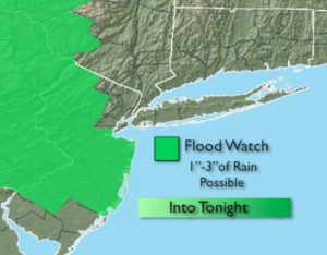
Strong high pressure over Southeastern Canada will continue to provide a cool flow off the Northern Atlantic. A complex low pressure system will move into and through the region today. This combination will keep on and off rain in the forecast through today. There will be dry times. The rain could come down heavy at times, especially North and West of the City. A Flood Watch remains in effect through today for much of NJ. Total rainfall will range from 1″-3″. The highest totals will be over Northwestern NJ. It’ll be windy at the coast with gusts up to 40mph. The winds will abate later this afternoon. Minor coastal flooding and rough seas are expected through tonight.
Scattered showers and storms are possible on Tuesday as moist flow and weakness remains over the area.
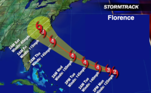
Hurricane Florence continues to rapidly strengthen in the Atlantic well South of Bermuda. Florence will once again become a major hurricane today and Category 4 status or higher is imminent (Winds above 131mph). The models are in very good agreement that the hurricane will move close to the Carolina’s later Thursday into Friday morning. Pinpoint location of possible landfall is a huge question that will need some time to answer.. We’ll continue to track. While we track, please don’t concentrate on the exact line (map above), but rather the yellow cone of uncertainty. The storm looks to stall and spin for possibly a couple of days after this time frame as steering currents in the upper atmosphere are weak to none. Will it be inland or just off the coast? Where this happens is still a important question that needs to be answered. Extreme rainfall amounts are possible where Florence possibly stalls. A major flooding event is possible. You know where to find a no hype, no nonsense forecast.
Stay tuned.
Today:
Periods of rain. There will be dry times. Cool. Windy at the coast. Highs in the upper 60s. East to Northeast winds at 15-25mph with gust to 40mph at the coast. Winds will abate during the afternoon.
Tonight:
Cloudy. Scattered showers. Becoming humid. Lows in the 60s throughout. East wind at 5-10mph.
Tuesday:
Mostly cloudy, warmer and more humid. Scattered showers and storms. Highs in the lower 80s.
Wednesday:
Partly sunny, warm and humid. Spotty storms. Highs in the lower to mid 80s.
Thursday:
Partly sunny, warm and humid. Highs in the lower to mid 80s.
Friday:
Partly sunny, warm and humid. Highs in the lower 80s.
Keep it here for a no nonsense, no hype forecast.