Synopsis:
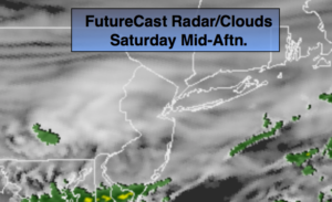
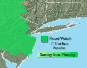
The weekend right now looks much cooler-it’ll be a Fall preview for sure. Strong high pressure over Southeastern Canada will provide a cool flow off the Atlantic. Plenty of moisture will be to our South with a stationary front. This combination will keep skies more grey than bright. There’s a chance of spotty showers this morning. Much of the afternoon should be dry for maybe the exception of Southern NJ. A swath of moisture will move into the region on Sunday. Intermittent rain in the morning will turn to a steadier rain by afternoon. Periods of heavy rain may occur later Sunday into a part of Monday. A Flood Watch has been posted for much of NJ into Monday. 1″-3″ of rain could fall.
Scattered showers and storms are possible on Tuesday. Unsettled times to say the least.
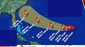
Tropical Storm Florence is churning in the far Atlantic. The storm should regain hurricane strength and has a decent chance to become a “major” status-Category 3 or higher hurricane. Many of today’s models have come in close proximity to the SouthEast coast- 6 days from now. It is way too early for any prognostication on the specific track. Focusing on one model run/track is scientifically indefensible. We’ll continue to track. Confidence has grown that the storm will not turn out to sea between Bermuda and the US mainland. The Carolina’s, at this time, have the greatest threat of a strike (map above). You know where to find a no hype, no nonsense forecast.
Stay tuned.
Today:
Mostly cloudy. Scattered showers in spots this morning. A few peeks of sun are possible this afternoon. Showers may continue over parts of Ocean county throughout the day. Cooler. Highs in the lower to mid 70s. North to Northeast winds at 10-15mph.
Tonight:
Cloudy with scattered showers. Much cooler. Lows in the upper 50s in the City. The mid 50s inland. Northeast wind at 10-15mph.
Sunday:
Cloudy with intermittent rain becoming steadier during the afternoon. Fall-like. Highs in the mid 60s. The average high for the date is 79º.
Monday:
Periods of rain. Highs in the lower 70s.
Tuesday:
Mostly cloudy, warmer and more humid. Scattered showers and storms. Highs in the lower 80s.
Wednesday:
Partly sunny, warm and humid. Highs in the mid 80s.
Keep it here for a no nonsense, no hype forecast.