Synopsis:
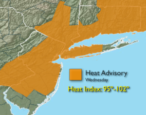
The heatwave will continue today as the bubble of hot air remains over the East coast. The combination of temperatures over 90º and high levels of humidity will result in a heat index in of 95º to 100º. The heat index will reach 100º-102º over parts of NJ. For this reason, a Heat Advisory has been posted.
An isolated afternoon and or evening storm is possible with a weak disturbance moving through. Most areas will remain dry.
Scattered showers and storms are likely tonight as a cool front approaches. Relief will arrive tomorrow with slightly lower temperatures and humidity.
Friday will be the best day of the bunch with more comfortable conditions.
The weekend looks unsettled as a weak low develops over the region. Scattered showers and storms are possible just about anytime.
Stay tuned.
Today:
Hazy, hot and humid. Highs around 90º. An isolated afternoon or evening storm is possible. Southwest winds at 5-10mph.
Tonight:
Scattered showers and storms. Lows in the mid 70s in the City, closer to 70º inland. Southwest to West winds 5-10mph.
Thursday:
Partly sunny, very warm and becoming less humid. Highs in the upper 80s to around 90º.
Friday:
Partly sunny with much lower humidity. Highs in the mid to upper 80s.
Saturday:
Mostly cloudy with scattered showers and isolated storms. Highs in the lower to mid 80s.
Sunday:
Mostly cloudy with scattered showers and isolated storms. Highs in the lower to mid 80s.
Keep it here for a no nonsense, no hype forecast.